

Croghan Hill [Cnoc Cruachain]
Good walks are even better shared.
Overview
Croghan Hill is an isolated 234 m hill in north County Offaly, rising above the pasture and peatlands of the Bog of Allen. Its volcanic origins, prehistoric burial mound and wide midland views make it a distinctive local walk from Croghan village.
Croghan Hill / Cnoc Cruacháin
Croghan Hill is an isolated 234 m hill in north County Offaly, rising above the pasture and peatlands of the Bog of Allen. Its grassy slopes lead to a hilltop with a prehistoric burial mound, an engraved interpretation pillar and wide views across the midlands. The Irish name Cnoc Cruacháin means “hill of the little stack”; Brí Éile is an older name.
Walking from Croghan village
Begin at Croghan Community Centre, a short walk west of the village crossroads. Walk to the crossroads information panel, then follow the signed access lane and marked farm route uphill to the permitted hilltop viewing area beside the burial mound and engraved pillar. Return by retracing the marked approach to the crossroads and community centre. Keep to the permitted path around the archaeological features; there is no need to climb the mound or pillar for the view.
This is a short but steep hill walk, with uneven surfaces and grassy sections. Wear walking footwear with good grip, particularly for the descent. The route crosses working farmland by permission: cattle graze here and dogs are not permitted. Respect gates, current signs and any access restrictions.
Summit and views
The grassy hilltop overlooks the surrounding low-lying countryside and Bog of Allen. The summit mound is believed to be a Bronze Age burial place. A modern pillar by artist Ciaran Byrne illustrates the hill’s volcanic origins and local stories. An old enclosed graveyard lies on the southeast slope. Leave stones, walls, monuments and grave markers undisturbed.
Geology
Croghan Hill is the remnant of a volcano that erupted in the sea covering this region around 340 million years ago, during the Carboniferous. Geological Survey Ireland records basaltic lava, volcanic ash and coarser volcanic deposits interbedded with limestone. This unusual geological history helps explain the hill’s prominence above the flatter surrounding landscape.
Getting there and facilities
Croghan village is on the southern side of the hill. Visit Offaly recommends parking at the community centre west of the crossroads. Follow local parking signs and keep entrances and farm access clear.
TFI Local Link Laois Offaly lists OY25, formerly 2326, between Ballybryan and Tullamore through Croghan on Tuesdays. This is an advance-booked service. Contact 057 8692168 by 4:30 pm the day before travel, and confirm both the outward and homeward journey. Check the operator’s current service information before planning a visit around it.
Bring drinking water and any food needed for the walk. The trail board points to services in Daingean, Rhode and Tyrrellspass.
History and tradition
The burial mound and nearby graveyard are part of a landscape with longstanding ceremonial and Christian associations. Local traditions connect the hill with Brigid, Patrick and Bishop MacCaille, and describe it as an inauguration place for the O’Connor rulers of Uí Failghe.
Oldcroghan Man, an Iron Age bog body, was discovered in the surrounding bogland in 2003. His remains were studied by the National Museum of Ireland and form part of its Kingship and Sacrifice interpretation. The discovery was separate from the hilltop burial mound.
Explore routes near Croghan Hill [Cnoc Cruachain]
Public walks starting within 80 km of this hill. Nearby does not mean a route reaches the summit; check its map and access before setting out.
No public routes are currently listed within 80 km of Croghan Hill [Cnoc Cruachain] on Walkmates. This does not mean there are no paths here. Explore the map and check local access information before planning a walk.
Route planning notes
These notes describe possible approaches, not verified navigable routes or permission to cross land. Check current paths, local access rules and conditions before setting out.
Croghan village marked hilltop approach and return
Start and finish at Croghan Community Centre, west of the village crossroads. Walk to the information panel at the crossroads, then follow the signed lane and marked farm route uphill to the permitted hilltop viewing area beside the burial mound and engraved pillar. Keep to the marked path around the archaeological features rather than climbing the mound or monument. Retrace the marked approach to the crossroads and community centre. The short climb has steep and uneven sections. Access across the working farmland is by permission, cattle graze here and dogs are not permitted; follow current signs and restrictions.
Make a day of it, together
Find someone to share the walk with, or organise a day out along a route you like.
Photo Gallery
View all Photo could not load
N4833 : Croghan Hill Co Offaly
Kenneth Gallery Smyth
Hill facts and local notes
Classifications
Elevation
234m
768 ft
Prominence
145m
Coordinates
53.3462, -7.2770
N482331
OS Map
48
At the Summit
The grassy hilltop has a burial mound believed to be Bronze Age and an engraved interpretation pillar by Ciaran Byrne. An old enclosed graveyard lies on the southeast slope. Use the permitted viewing area and leave the mound, monuments and grave markers undisturbed.
Terrain & Geology
Geological Survey Ireland describes Croghan Hill as the remains of a volcano that erupted into the sea around 340 million years ago, during the Carboniferous. Basaltic lava and volcanic ash and fragment deposits occur with limestone, above the surrounding low pasture and peatlands.
Views & Scenery
The open hilltop gives wide views across the surrounding midland countryside and the low-lying Bog of Allen in clear weather.
History & Heritage
Name Origin
Cnoc Cruacháin means “hill of the little stack”. Brí Éile is an earlier Irish name for the hill.
Historical Significance
The summit mound is believed to be a Bronze Age burial place. Local traditions associate the hill with Brigid, Patrick and Bishop MacCaille, and with the inauguration of the O’Connor rulers of Uí Failghe. Oldcroghan Man, an Iron Age bog body, was discovered in the surrounding bogland in 2003 and studied by the National Museum of Ireland; the find was separate from the summit mound.
Getting There & Facilities
Check current local access restrictions, parking rules and transport timetables before travelling. These notes do not confirm public access to the summit.
Parking
Visit Offaly recommends Croghan Community Centre, a short walk west of the village crossroads. Walk to the information panel at the crossroads to join the signed approach. Follow local parking signs and keep entrances and farm access clear.
Public Transport
TFI Local Link Laois Offaly lists Tuesday service OY25, formerly 2326, between Ballybryan and Tullamore through Croghan. Book on 057 8692168 by 4:30 pm the day before travel, and confirm both the outward and homeward journey.
Nearby Facilities
Bring drinking water and any food needed for the walk. The official trail board points to services in Daingean, Rhode and Tyrrellspass.
Safety Information
Known Hazards
- The approach has steep, uneven ground and grassy sections that can become slippery when wet; wear footwear with good grip.
- Cattle graze on the hill. Keep to the marked route through the working farmland; dogs are not permitted.
- Leave the archaeological mound, stones, walls and grave markers undisturbed. Respect current access signs and restrictions.
General Safety Tips
- Check weather conditions before setting out
- Carry appropriate clothing and equipment
- Let someone know your planned route
- Take a map, compass, and GPS device
- Carry emergency supplies: food, water, first aid kit, torch
Hills
Some common questions about the hills answered
Are there group walks up Croghan Hill [Cnoc Cruachain]?
Many walkers use Walkmates to join or organise walks with others. You can check for group walks around Croghan Hill [Cnoc Cruachain] through the maps
Are there other walkers around Croghan Hill [Cnoc Cruachain]?
Activity varies by location and time, but Walkmates lets you see whether others have shared walks or shown interest in this area. Find other people through the walking friends search walking friends for Croghan Hill [Cnoc Cruachain] search or of course create your own walk for Croghan Hill [Cnoc Cruachain]
Can I organise a walk to Croghan Hill [Cnoc Cruachain]?
Yes. If there aren’t any walks listed already, you can create a walk and make it available for others to join.
If you're signed up to Walkmates, you can create a walk to Croghan Hill [Cnoc Cruachain].
How do I find a walk up this hill?
There are often multiple ways to walk this hill, depending on experience and route preference. Walkmates helps you explore walks and routes that others have shared.
Can I suggest a new route up Croghan Hill [Cnoc Cruachain]?
Yes. You can suggest or create routes to share with others. Walkmates focuses on the social side of walking, so routes are used to help people organise walks and explore areas together, rather than as detailed navigation tools or route libraries.
Other uses really appreciate knowledgeable walkers sharing their routes. Share your favourite route to Croghan Hill [Cnoc Cruachain] here
The is an error or something incorrect about this hill. How do I let you know?
We always strive to keep the information on Walkmates as accurate as possible. If you find an error, please let us know through the contact form and we'll aim to correct it as quickly as possible
Community Discussion
Comments
Location
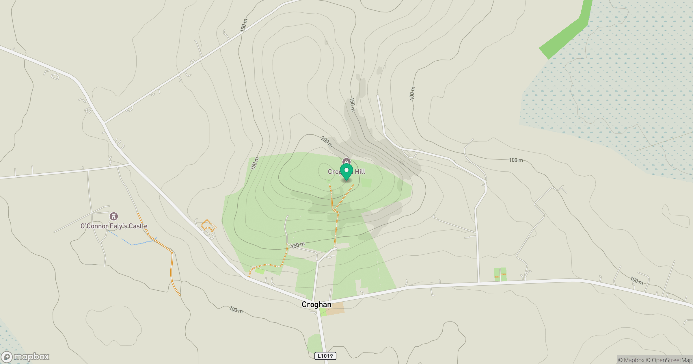
Grid reference: N482331
View on OpenStreetMapOpens a map in a new tab, centred on the hill.
Hills within 30 km
Straight-line distance, not a walking route or confirmation of access.
No comments yet. Be the first.